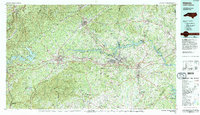
1986 Map of Hickory
USGS Topo · Published 1995About this map
Hickory and its neighboring furniture and textile centers of Lenoir, Morganton, and Newton form the industrial heart of this Foothills region during the mid-1980s. The Catawba River is the defining geographical feature, harnessed into a series of reservoirs including Lake James, Lake Rhodhiss, Lake Hickory, and Lookout Shoals Lake. These water bodies, along with the Southern Railway corridor, dictated the growth patterns of towns like Valdese, Conover, and Maiden.
Find a feature on this map
118 named features on this map. Tap any name to fly to it.
Don’t see what you’re looking for? This feature index may not catch every label — zoom into the map to look around manually.
Map Details
Editions of this 1986 Hickory Map
3 editions found
Other maps of this area

1889 · Wilkesboro
USGS Topo · 1:125,000

1891 · Roan Mountain
USGS Topo · 1:125,000

1891 · Wilkesboro
USGS Topo · 1:125,000

1891 · Yadkinville
USGS Topo · 1:125,000

1893 · Cranberry
USGS Topo · 1:125,000

1893 · Statesville
USGS Topo · 1:125,000

1893 · Yadkinville
USGS Topo · 1:125,000

1894 · Roan Mountain
USGS Topo · 1:125,000

1895 · Hickory
USGS Topo · 1:125,000

1895 · Cranberry
USGS Topo · 1:125,000