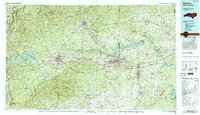
1986 Map of Hickory
USGS Topo · Published 1995About this map
The Catawba River serves as the central artery for this mid-1980s landscape, connecting a chain of significant reservoirs including Lake James, Rhodhiss Lake, and Lake Hickory. This industrial and recreational corridor links the manufacturing hubs of Hickory, Lenoir, and Morganton. The terrain is defined by the dramatic ascent of the Blue Ridge and Linville Mountain to the west, while the Brushy Mountains and South Mountains frame the central valleys.
Find a feature on this map
149 named features on this map. Tap any name to fly to it.
Don’t see what you’re looking for? This feature index may not catch every label — zoom into the map to look around manually.
Map Details
Editions of this 1986 Hickory Map
3 editions found
Other maps of this area

1889 · Wilkesboro
USGS Topo · 1:125,000

1891 · Roan Mountain
USGS Topo · 1:125,000

1891 · Wilkesboro
USGS Topo · 1:125,000

1891 · Yadkinville
USGS Topo · 1:125,000

1893 · Cranberry
USGS Topo · 1:125,000

1893 · Statesville
USGS Topo · 1:125,000

1893 · Yadkinville
USGS Topo · 1:125,000

1894 · Roan Mountain
USGS Topo · 1:125,000

1895 · Hickory
USGS Topo · 1:125,000

1895 · Cranberry
USGS Topo · 1:125,000