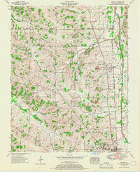
1951 Map of Hickory
USGS Topo · Published 1967About this map
Hickory and the surrounding Graves County landscape appear here during a period of steady post-war agricultural and industrial activity. The corridor is defined by the Illinois Central railroad, which links the northern settlements of Viola and West Viola to the larger hub of Mayfield in the south. This transportation spine is punctuated by local industry, notably the Clay pits near Trinity Ch, reflecting the region's known geological resources.
Find a feature on this map
52 named features on this map. Tap any name to fly to it.
Don’t see what you’re looking for? This feature index may not catch every label — zoom into the map to look around manually.
Map Details
Editions of this 1951 Hickory Map
2 editions found
Other maps of this area

1936 · Farmington
USGS Topo · 1:24,000

1936 · Melber
USGS Topo · 1:24,000

1936 · Symsonia
USGS Topo · 1:24,000

1936 · Westplains
USGS Topo · 1:24,000

1951 · Farmington
USGS Topo · 1:24,000

1951 · Melber
USGS Topo · 1:24,000

1951 · Hickory
USGS Topo · 1:24,000
1951 · Symsonia
USGS Topo · 1:24,000
1951 · Westplains
USGS Topo · 1:24,000

1951 · Hickory
USGS Topo · 1:62,500