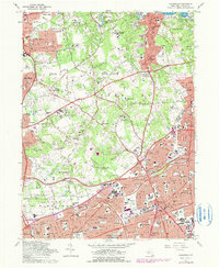
1967 Map of Hicksville
USGS Topo · Published 1979About this map
Long Island suburbanization and the post-war transportation network define this landscape on the cusp of the 1980s. The major arterial routes of the Northern State Parkway and Long Island Expressway slice through the region, facilitating the rapid growth of communities like Hicksville and Jericho. While the southern portion of the sheet shows dense residential development around the Long Island Rail Road, the northern reaches retain a legacy of large estates and institutional land use. This is evident in the numerous golf courses like Piping Rock Country Club and the sprawling campus of the State University College at Old Westbury. Genealogists will find a wealth of local landmarks, including several burial grounds such as St Patrick Cem and Holy Rood Cemetery, alongside a dense network of local schools serving the mid-century population boom.
Find a feature on this map
112 named features on this map. Tap any name to fly to it.
Don’t see what you’re looking for? This feature index may not catch every label — zoom into the map to look around manually.
Map Details
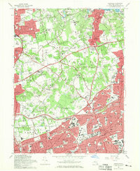
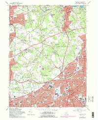
Editions of this 1967 Hicksville Map
3 editions found
Other maps of this area

1897 · Hempstead
USGS Topo · 1:62,500

1897 · Oyster Bay
USGS Topo · 1:62,500

1898 · Hempstead
USGS Topo · 1:62,500

1898 · Oyster Bay
USGS Topo · 1:62,500

1899 · Hempstead
USGS Topo · 1:62,500

1900 · Oyster Bay
USGS Topo · 1:62,500

1901 · Babylon
USGS Topo · 1:62,500

1901 · Northport
USGS Topo · 1:62,500
1903 · Babylon
USGS Topo · 1:62,500

1903 · Northport
USGS Topo · 1:62,500