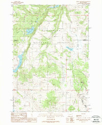
1988 Map of Hidden Lake Bench
USGS Topo · Published 1988About this map
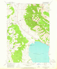
Deer Mountain and the high plateaus of the Beaverhead National Forest dominate this high-altitude landscape along the Montana and Idaho border. The map illustrates a complex network of glacial basins and drainage systems, featuring Hidden Lake and the smaller Goose Lake and Other Lake tucked beneath steep slopes. A significant portion of the western boundary is protected by the Red Rock Lakes National Wildlife Refuge, while the southern reaches drop toward the shores of Henrys Lake in the Targhee National Forest. Mining history is evidenced by the Lost Mine situated near the head of a remote canyon. The presence of several quarries and a system of primitive 4WD tracks suggests a landscape primarily utilized for natural resource extraction and rugged recreational access. The Continental Divide weaves across the southeastern corner, marking the topographic spine of the region near Saddle Mountain.
Find a feature on this map
31 named features on this map. Tap any name to fly to it.
Don’t see what you’re looking for? This feature index may not catch every label — zoom into the map to look around manually.
Map Details
Editions of this 1988 Hidden Lake Bench Map
This is the sole edition of this map. No revisions or reprints were ever made.
Other maps of this area
1950 · Cliff Lake
USGS Topo · 1:62,500
1950 · Hebgen Dam
USGS Topo · 1:62,500
1950 · Upper Red Rock Lake
USGS Topo · 1:62,500

1955 · Ashton
USGS Topo · 1:250,000

1958 · Ashton
USGS Topo · 1:250,000

1960 · Ashton
USGS Topo · 1:250,000
1964 · Targhee Peak
USGS Topo · 1:24,000
1964 · Sawtell PK
USGS Topo · 1:24,000
1964 · Henrys Lake
USGS Topo · 1:62,500
1988 · Freezeout Mountain
USGS Topo · 1:24,000