
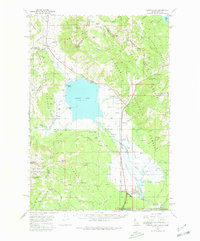
1964 Map of Henrys Lake
USGS Topo · Published 1972About this map
Henrys Lake dominates this high-altitude landscape where the Continental Divide Trail snakes along the crest of the Gallatin National Forest and Targhee National Forest. The map reflects a mid-20th-century transition between traditional ranching and modern recreation, evidenced by the presence of the Johnson Ranch and Webster Ranch alongside the Lionhead Ski Area and the Island Park Golf Course. Significant landmarks like Targhee Pass and Sawtell Peak define the horizon, while the small settlement of Henry and the Targhee Cem provide a human anchor to this mountain environment. The intricate drainage network, including the Henrys Lake Outlet and Crooked Creek, showcases the hydrography of the Idaho-Montana borderlands during the early 1960s.
Find a feature on this map
98 named features on this map. Tap any name to fly to it.
Don’t see what you’re looking for? This feature index may not catch every label — zoom into the map to look around manually.
Map Details
Editions of this 1964 Henrys Lake Map
2 editions found
Other maps of this area

1950 · Cliff Lake
USGS Topo · 1:62,500

1950 · Hebgen Dam
USGS Topo · 1:62,500

1950 · Upper Red Rock Lake
USGS Topo · 1:62,500

1955 · Ashton
USGS Topo · 1:250,000

1957 · Buffalo Lake
USGS Topo · 1:62,500

1958 · Ashton
USGS Topo · 1:250,000

1958 · West Yellowstone
USGS Topo · 1:62,500
1958 · Tepee Creek
USGS Topo · 1:62,500

1960 · Ashton
USGS Topo · 1:250,000

1964 · Island Park
USGS Topo · 1:24,000