
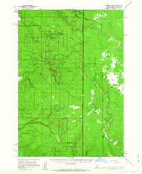
1957 Map of Buffalo Lake
USGS Topo · Published 1959About this map
The Continental Divide serves as the focal point of this 1957 field survey, where the borders of Idaho, Montana, and Wyoming converge in a high-elevation wilderness. This landscape is defined by the intersection of the Targhee National Forest and Yellowstone National Park, capturing the hydrologic headwaters of several major drainages. Notable water features include Buffalo Lake and the complex branching of the North Fork, Middle Fork, and South Fork of the Snake River watershed. The map records a time when human presence was limited to remote infrastructure, such as the Patrol Cabin and various jeep trails and footpaths. Topographical highlights like the Madison Plateau and Moose Creek Plateau are detailed alongside specific named points like Black Mtn and Snow Creek Butte, illustrating the varied terrain of the northern Rockies before modern development reached these borders.
Find a feature on this map
38 named features on this map. Tap any name to fly to it.
Don’t see what you’re looking for? This feature index may not catch every label — zoom into the map to look around manually.
Map Details
Editions of this 1957 Buffalo Lake Map
2 editions found
Other maps of this area

1885 · Gallatin
USGS Topo · 1:125,000

1885 · Gallatin
USGS Topo · 1:125,000

1886 · Shoshone
USGS Topo · 1:125,000

1888 · Shoshone
USGS Topo · 1:125,000

1895 · Shoshone
USGS Topo · 1:125,000

1901 · Shoshone
USGS Topo · 1:125,000

1901 · Gallatin
USGS Topo · 1:125,000

1908 · Gallatin
USGS Topo · 1:125,000

1908 · Shoshone
USGS Topo · 1:125,000

1911 · Shoshone
USGS Topo · 1:125,000