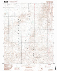
1996 Map of Hidden Spring
USGS Topo · Published 1998About this map
Hidden Spring serves as a central landmark in this desert terrain, where the northern reaches of the Quail Mountains meet the southern edge of Long Valley. This 1996 photoinspection reveals a landscape defined by its transition from military and naval jurisdiction to the open desert. The U S Naval Reservation dominates the western and central portions of the map, while the Fort Irwin Military Reservation occupies the southeast. Evidence of earlier human activity is visible along the Old Railroad Grade and at a site of Ruins in the northern valley. The topography is anchored by the Brown Mountain range to the west and the Owl Shead Mountains to the east, with the San Bernardino Meridian cutting a straight north-south line through the high desert floor.
Find a feature on this map
13 named features on this map. Tap any name to fly to it.
Don’t see what you’re looking for? This feature index may not catch every label — zoom into the map to look around manually.
Map Details
Editions of this 1996 Hidden Spring Map
This is the sole edition of this map. No revisions or reprints were ever made.
Other maps of this area

1915 · Searles Lake
USGS Topo · 1:250,000

1933 · Avawatz Mountains
USGS Topo · 1:250,000

1947 · Trona
USGS Topo · 1:250,000

1948 · Trona
USGS Topo · 1:250,000

1948 · Quail Mountains
USGS Topo · 1:62,500

1950 · Manly Peak
USGS Topo · 1:62,500

1950 · Wingate Wash
USGS Topo · 1:62,500

1950 · Wingate Pass
USGS Topo · 1:62,500

1951 · Wingate Pass
USGS Topo · 1:62,500

1951 · Quail Mountains
USGS Topo · 1:62,500