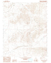
1982 Map of Hidden Valley West
USGS Topo · Published 1993About this map
The Cady Mountains dominate this high-desert landscape in San Bernardino County, where drainage patterns define the arid environment. Along the northwestern edge, the Mojave River is a primary landmark, featuring the Ninemile Waterhole, an essential water source in an otherwise parched corridor. The terrain is marked by seasonal drainages like Wilhelm Wash that cut through the elevation toward the southeastern expanse of Hidden Valley. Evidence of small-scale mineral exploration is present throughout the hills, indicated by various Prospects scattered among the peaks and washes. This 1980s-era survey represents the desert just before significant modern shifts in land management, showing a territory primarily shaped by natural topography and the search for minerals.
Find a feature on this map
6 named features on this map. Tap any name to fly to it.
Don’t see what you’re looking for? This feature index may not catch every label — zoom into the map to look around manually.
Map Details
Editions of this 1982 Hidden Valley West Map
3 editions found
Other maps of this area

1933 · Avawatz Mountains
USGS Topo · 1:250,000

1947 · Trona
USGS Topo · 1:250,000

1948 · Trona
USGS Topo · 1:250,000

1948 · Alvord Mountain
USGS Topo · 1:62,500

1948 · Cave Mountain
USGS Topo · 1:62,500

1951 · Cave Mountain
USGS Topo · 1:62,500

1951 · Alvord Mountain
USGS Topo · 1:62,500

1953 · San Bernardino
USGS Topo · 1:250,000

1953 · Trona
USGS Topo · 1:250,000

1955 · Newberry
USGS Topo · 1:62,500