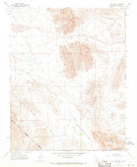
1968 Map of High Peak
USGS Topo · Published 1970About this map
Resting Spring Range defines the southwestern corner of this desert landscape, where the rugged topography meets the arid floor of Stewart Valley (Depression). The map highlights a significant historical boundary, the Von Schmidt Line, which cuts diagonally across the terrain to mark the separation between California and Nevada. This boundary, surveyed in the late 19th century, remains a critical landmark for local land records and regional history. Travel through this sparse environment is traced by the Old Traction Road and Ash Meadows Road, which provided vital routes through the basin. Near the eastern peaks, a lone Prospect indicates the area's history of mineral exploration, while High Peak stands as the primary topographical landmark overlooking the valley floor. The map captures a moment of transition where established state lines and early industrial trails intersect in the remote Great Basin.
Find a feature on this map
9 named features on this map. Tap any name to fly to it.
Don’t see what you’re looking for? This feature index may not catch every label — zoom into the map to look around manually.
Map Details
Editions of this 1968 High Peak Map
2 editions found
Other maps of this area

1908 · Furnace Creek
USGS Topo · 1:250,000

1910 · Furnace Creek
USGS Topo · 1:250,000

1940 · Eagle Tank
USGS Topo · 1:62,500

1948 · Death Valley
USGS Topo · 1:250,000

1951 · Eagle Mtn
USGS Topo · 1:62,500

1952 · Ash Meadows
USGS Topo · 1:62,500

1954 · Death Valley
USGS Topo · 1:250,000

1956 · Death Valley
USGS Topo · 1:250,000

1957 · Death Valley
USGS Topo · 1:250,000

1958 · Death Valley
USGS Topo · 1:250,000