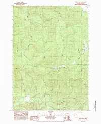
1984 Map of High Point
USGS Topo · Published 1984About this map
Alma and the small settlement of Wolf Creek anchor this mid-1980s look at the drainage basins of the Siuslaw River in the Siuslaw National Forest. The landscape is defined by its complex network of named drainages, including Wildcat Creek, Swamp Creek, and Pheasant Creek, which flow through heavily contoured terrain. Notable landmarks like Timber Ridge and High Point illustrate the area's elevation, while infrastructure such as Panther Road and the Mainline timber access routes reveal the region's industrial connection to the woods.
Find a feature on this map
33 named features on this map. Tap any name to fly to it.
Don’t see what you’re looking for? This feature index may not catch every label — zoom into the map to look around manually.
Map Details
Editions of this 1984 High Point Map
This is the sole edition of this map. No revisions or reprints were ever made.
Other maps of this area

1909 · Elmira
USGS Topo · 1:62,500

1922 · Elmira
USGS Topo · 1:62,500

1941 · Blachly
USGS Topo · 1:62,500

1942 · Elmira
USGS Topo · 1:62,500

1942 · Blachly
USGS Topo · 1:62,500

1942 · Crow
USGS Topo · 1:62,500

1942 · Roman Nose Mtn
USGS Topo · 1:62,500

1945 · Crow
USGS Topo · 1:62,500

1945 · Roman Nose Mtn
USGS Topo · 1:62,500

1953 · Salem
USGS Topo · 1:250,000