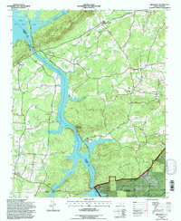
1994 Map of High Rock
USGS Topo · Published 1996About this map
Healing Springs and the northern reaches of the Uwharrie National Forest anchor this mid-1990s study of the riverine landscape where Davidson, Rowan, and Montgomery counties meet. The geography is dominated by the Yadkin River and its impoundments, with High Rock Lake and the Tuckertown Reservoir shaping the local economy and recreation. The Winston-Salem Southbound railroad follows the eastern bank of the reservoirs, connecting small settlements like Newsom and Ellis. Along the western edge, High Rock Mountain rises sharply above the water, while rural life is marked by numerous country churches such as Lick Creek Ch, Antioch Ch, and Pleasant Grove Ch. The presence of the High Rock Lake Dam and the Stokes Ferry Bridge highlights the critical infrastructure managing the river's flow and regional transit during this era.
Find a feature on this map
37 named features on this map. Tap any name to fly to it.
Don’t see what you’re looking for? This feature index may not catch every label — zoom into the map to look around manually.
Map Details
Editions of this 1994 High Rock Map
This is the sole edition of this map. No revisions or reprints were ever made.
Other maps of this area

1949 · High Rock
USGS Topo · 1:24,000

1949 · Denton NW
USGS Topo · 1:24,000

1953 · Charlotte
USGS Topo · 1:250,000

1954 · Charlotte
USGS Topo · 1:250,000

1957 · Mount Pleasant
USGS Topo · 1:62,500

1957 · Albemarle
USGS Topo · 1:62,500

1957 · Denton
USGS Topo · 1:62,500

1960 · Charlotte
USGS Topo · 1:250,000

1962 · Charlotte
USGS Topo · 1:250,000

1962 · Southmont
USGS Topo · 1:24,000