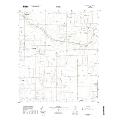
2021 Map of High Springs SW
USGS Topo · Published 2021About this map
The Santa Fe River carves a winding path through the northern reaches of this landscape, its banks dotted with unique hydrological features like Ginnie Spring, Blue Springs, and Lilly Spring. This river corridor serves as a primary geographical anchor, where Rum Island and Hollingsworth Bluff overlook the water near the Gilchrist Co and Columbia Co lines. To the east, the River Rise Preserve State Park preserves the area's native character where the river's path becomes more complex.
Find a feature on this map
143 named features on this map. Tap any name to fly to it.
Don’t see what you’re looking for? This feature index may not catch every label — zoom into the map to look around manually.
Map Details
Editions of this 2021 High Springs SW Map
This is the sole edition of this map. No revisions or reprints were ever made.
Other maps of this area

1954 · Gainesville
USGS Topo · 1:250,000

1958 · Gainesville
USGS Topo · 1:250,000

1959 · Gainesville
USGS Topo · 1:250,000

1962 · High Springs
USGS Topo · 1:24,000

1962 · Mikesville
USGS Topo · 1:24,000

1968 · Waters Lake
USGS Topo · 1:24,000

1968 · Newberry
USGS Topo · 1:24,000

1968 · Fourmile Lake
USGS Topo · 1:24,000
1968 · Hildreth
USGS Topo · 1:24,000
1968 · Bell
USGS Topo · 1:24,000