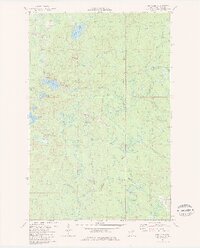
1981 Map of Highland
USGS Topo · Published 1982About this map
The Duluth Missabe and Iron Range Railroad defines the industrial and transit corridor of this Lake County landscape during the early 1980s. Small settlements like Wales, Highland, and Alger are situated along this critical rail line, which served the region's iron ore economy. The map reveals a transition between active industrial infrastructure and the natural watershed of the North Shore, evidenced by the Old Railroad Grade and numerous water bodies such as Thomas Lake and Highland Lake. Natural drainage is prominent, with the Gooseberry River, Silver Creek, and Stewart River carving paths toward Lake Superior. Local landmarks including the Flying Sportsman Airport and Radio Towers near Highland highlight the area's mid-century development. This survey serves as a record of the region before significant changes in timber management and recreational land use further altered the character of these small rail-stop communities.
Find a feature on this map
23 named features on this map. Tap any name to fly to it.
Don’t see what you’re looking for? This feature index may not catch every label — zoom into the map to look around manually.
Map Details
Editions of this 1981 Highland Map
This is the sole edition of this map. No revisions or reprints were ever made.
Other maps of this area

1953 · Whyte
USGS Topo · 1:62,500

1954 · Mc Carthy Creek
USGS Topo · 1:24,000

1954 · Two Harbors
USGS Topo · 1:250,000

1956 · King Lake
USGS Topo · 1:24,000

1957 · Two Harbors
USGS Topo · 1:250,000

1957 · Two Harbors
USGS Topo · 1:62,500

1957 · Two Harbors
USGS Topo · 1:24,000

1957 · Brimson
USGS Topo · 1:62,500

1957 · Two Harbors NE
USGS Topo · 1:24,000

1957 · Castle Danger
USGS Topo · 1:24,000