
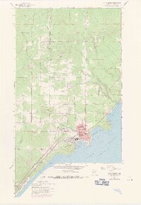
1957 Map of Two Harbors
USGS Topo · Published 1958About this map
Two Harbors serves as the industrial and logistical anchor for this 1950s Lake County shoreline, where the massive infrastructure of the Duluth Missabe and Iron Range Railroad meets the deep waters of Agate Bay and Burlington Bay. The town's grid is dense with civic and social landmarks, including the High Sch, Johnson Sch, and a central Hospital, supporting a population centered around the rail yards and the lakefront Waterworks. A prominent Lighthouse stands at the tip of the breakwater, guiding traffic into the iron-ore port.
Find a feature on this map
37 named features on this map. Tap any name to fly to it.
Don’t see what you’re looking for? This feature index may not catch every label — zoom into the map to look around manually.
Map Details
Editions of this 1957 Two Harbors Map
2 editions found
Other maps of this area

1953 · Knife River
USGS Topo · 1:24,000

1953 · Ashland
USGS Topo · 1:250,000

1954 · Mc Carthy Creek
USGS Topo · 1:24,000

1954 · Two Harbors
USGS Topo · 1:250,000

1956 · King Lake
USGS Topo · 1:24,000

1957 · Two Harbors
USGS Topo · 1:250,000

1957 · Two Harbors
USGS Topo · 1:62,500

1957 · Two Harbors NE
USGS Topo · 1:24,000

1957 · Castle Danger
USGS Topo · 1:24,000

1958 · Ashland
USGS Topo · 1:250,000