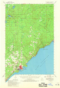
1957 Map of Two Harbors
USGS Topo · Published 1968About this map
Two Harbors serves as the focal point of this coastal Minnesota survey, showing the intensive maritime and rail infrastructure that defined the North Shore in the mid-1950s. The shoreline along Lake Superior is marked by significant landmarks including the Lighthouse at Agate Bay, Lakeview Park, and the Fairground. To the north, the landscape transitions into a network of creek valleys and ridges, with notable coastal features like Silver Cliff, Lafayette Bluff, and the prominent Encampment Island. The industrial and logistics-heavy nature of the area is evident in the presence of the Duluth Missabe and Iron Range railroad and numerous inland settlements such as Waldo, Alger, and Wales. Beyond the urban core, smaller local centers are represented by features like Johnson Sch and the remote Beaver Crossing lookout tower near the northern edge of the map.
Find a feature on this map
57 named features on this map. Tap any name to fly to it.
Don’t see what you’re looking for? This feature index may not catch every label — zoom into the map to look around manually.
Map Details
Editions of this 1957 Two Harbors Map
2 editions found

Other maps of this area

1943 · Port Wing
USGS Topo · 1:48,000

1946 · Port Wing
USGS Topo · 1:48,000

1953 · Knife River
USGS Topo · 1:24,000

1953 · Whyte
USGS Topo · 1:62,500

1953 · Ashland
USGS Topo · 1:250,000

1954 · Mc Carthy Creek
USGS Topo · 1:24,000

1954 · Silver Bay
USGS Topo · 1:62,500

1954 · Two Harbors
USGS Topo · 1:250,000

1956 · Split Rock Point
USGS Topo · 1:24,000

1956 · King Lake
USGS Topo · 1:24,000