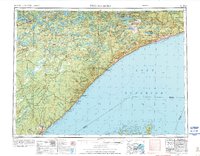
1954 Map of Two Harbors
USGS Topo · Published 1975About this map
Superior National Forest dominates this mid-century look at the North Shore, where the heavy industry of the Duluth Missabe and Iron Range Railroad meets the vastness of Lake Superior. The map details the transition from the iron-rich interior near Ely and Winton to the maritime hubs of Two Harbors and Grand Marais. In the rugged backcountry, high points like Eagle Mtn and the Misquah Hills overlook an intricate system of drainages including the Isabella River and Temperance River. Along the coast, the presence of the U S Air Force Radar Station and Skyport Lodge reflect the mid-century's strategic and recreational development. Maritime history is marked by icons like Split Rock Light and the prominent cliffs of Palisade Head, while the interior shows the localized activity of the Jack Pine Min.
Find a feature on this map
76 named features on this map. Tap any name to fly to it.
Don’t see what you’re looking for? This feature index may not catch every label — zoom into the map to look around manually.
Map Details
Editions of this 1954 Two Harbors Map
2 editions found

Other maps of this area

1895 · Duluth
USGS Topo · 1:62,500

1919 · Brule Lake
USGS Topo · 1:62,500

1919 · Grand Marais
USGS Topo · 1:62,500

1919 · Lutsen
USGS Topo · 1:62,500

1933 · Ely
USGS Topo · 1:62,500

1939 · Ely
USGS Topo · 1:62,500

1941 · Bayfield
USGS Topo · 1:48,000

1943 · Port Wing
USGS Topo · 1:48,000

1944 · Cornucopia
USGS Topo · 1:48,000

1946 · Cornucopia
USGS Topo · 1:48,000