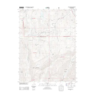
2013 Map of Highland Peak
USGS Topo · Published 2013About this map
Highland Peak and the surrounding high-altitude drainage basins of the White River National Forest dominate this 2013 landscape. The terrain is defined by a complex network of historic water management features, including the McKenzie Wildcat Ditch, Elk Cr Ditch, and Willow and Owl Ditch, which redirect snowmelt across the slopes. Settlement is concentrated in the northern reaches at Cozy Point and along the winding Brush Creek Rd, while the southern portion of the quadrangle remains largely roadless, save for established routes like Government Trail 1980.1. The map documents the vital intersection of recreation and utility, showing seasonal sites such as Elk Camp alongside significant water bodies like Wildcat Reservoir and Whites Lake. The presence of several Maroon Creek Campgrounds at the eastern edge highlights the area's role as a gateway to the alpine wilderness.
Find a feature on this map
86 named features on this map. Tap any name to fly to it.
Don’t see what you’re looking for? This feature index may not catch every label — zoom into the map to look around manually.
Map Details
Editions of this 2013 Highland Peak Map
This is the sole edition of this map. No revisions or reprints were ever made.
Other maps of this area

1893 · Aspen
USGS Topo · 1:62,500

1895 · Aspen
USGS Topo · 1:62,500

1909 · Mount Jackson
USGS Topo · 1:125,000

1911 · Mount Jackson
USGS Topo · 1:125,000

1957 · Leadville
USGS Topo · 1:250,000

1959 · Leadville
USGS Topo · 1:250,000

1960 · Leadville
USGS Topo · 1:250,000

1960 · Highland Peak
USGS Topo · 1:24,000

1960 · Maroon Bells
USGS Topo · 1:24,000
1960 · Hayden Peak
USGS Topo · 1:24,000