
1959 Map of Highlands Church
USGS Topo · Published 1960About this map
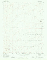
Highlands Church serves as the focal point for this rural landscape in eastern Pueblo County, surveyed in the late 1950s. The area is characterized by a network of drainage patterns, most notably the winding path of Kramer Creek that cuts through the southeastern quadrant. Settlement is sparse, reflected by the isolated placement of a small Cem and the presence of numerous Fence lines and a winding Trail, which suggest a terrain primarily used for open-range grazing or agriculture rather than dense development. The survey also identifies the prominent high point at VABM Stroud 5145, providing a clear record of the natural topography before more modern land-use changes altered the quiet character of this plains environment.
Find a feature on this map
8 named features on this map. Tap any name to fly to it.
Don’t see what you’re looking for? This feature index may not catch every label — zoom into the map to look around manually.
Map Details
Editions of this 1959 Highlands Church Map
2 editions found
Other maps of this area

1891 · Nepesta
USGS Topo · 1:125,000

1893 · Nepesta
USGS Topo · 1:125,000

1893 · Big Springs
USGS Topo · 1:125,000

1904 · Nepesta
USGS Topo · 1:125,000

1954 · Pueblo
USGS Topo · 1:250,000

1957 · Pueblo
USGS Topo · 1:250,000

1958 · Pueblo
USGS Topo · 1:250,000
1959 · Grandview School
USGS Topo · 1:24,000

1959 · North Avondale NE
USGS Topo · 1:24,000
1960 · Boone Hill
USGS Topo · 1:24,000