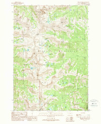
1988 Map of Hilgard Peak
USGS Topo · Published 1989About this map
Hilgard Peak stands as the dramatic centerpiece of this high-altitude landscape along the Madison and Gallatin county line. The territory is defined by the Lee Metcalf Wilderness, where the sharp ridges of the Madison Range divide the drainage basins of Beaverhead National Forest and Gallatin National Forest. This late-1980s topographic survey meticulously records a high-alpine environment carved by glacial action, resulting in a dense concentration of cirque lakes such as Thunderbolt Lake, Blue Paradise Lake, and Expedition Lake. The naming conventions found here, including Imp Peak, Echo Peak, and Dutchman Peak, suggest a history of early mountaineering and exploration. Small alpine meadows like Sedge Meadow Creek provide contrast to the steep rocky spires, while the network of trails and wilderness boundaries illustrates the preservation of this remote Montana backcountry during the late twentieth century.
Find a feature on this map
56 named features on this map. Tap any name to fly to it.
Don’t see what you’re looking for? This feature index may not catch every label — zoom into the map to look around manually.
Map Details
Editions of this 1988 Hilgard Peak Map
2 editions found
Other maps of this area

1888 · Three Forks
USGS Topo · 1:250,000

1894 · Three Forks
USGS Topo · 1:250,000

1895 · Three Forks
USGS Topo · 1:250,000

1947 · Bozeman
USGS Topo · 1:250,000

1948 · Bozeman
USGS Topo · 1:250,000

1950 · Cliff Lake
USGS Topo · 1:62,500

1950 · Hebgen Dam
USGS Topo · 1:62,500

1950 · Cameron
USGS Topo · 1:62,500

1950 · Sphinx Mountain
USGS Topo · 1:62,500

1955 · Bozeman
USGS Topo · 1:250,000