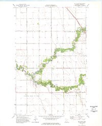
1974 Map of Hill Siding
USGS Topo · Published 1976About this map
The North Branch Two Rivers snakes across this Kittson County landscape, defining the character of the terrain just east of the Red River. In this mid-1970s survey, the small settlements of Northcote and Hill Siding serve as the primary hubs along the Burlington Northern railroad line. The map captures a highly engineered agricultural landscape, marked by a systematic network of drainage projects including Co Ditch No 26, Ditch No 13, and Co Ditch No 21. These channels contrast sharply with the tight, natural meanders of the river. Infrastructure of the era is represented by a prominent Pipeline, a Radio Tower, and a Pumping Station, illustrating the rural industrial footprint of the northern Red River Valley during this period of Minnesota's history.
Find a feature on this map
14 named features on this map. Tap any name to fly to it.
Don’t see what you’re looking for? This feature index may not catch every label — zoom into the map to look around manually.
Map Details
Editions of this 1974 Hill Siding Map
This is the sole edition of this map. No revisions or reprints were ever made.
Other maps of this area

1939 · Drayton
USGS Topo · 1:62,500

1939 · Pembina
USGS Topo · 1:62,500

1939 · Kennedy
USGS Topo · 1:62,500

1941 · Kennedy
USGS Topo · 1:62,500

1941 · Drayton
USGS Topo · 1:62,500

1941 · Hallock
USGS Topo · 1:62,500

1941 · Pembina
USGS Topo · 1:62,500

1952 · Thief River Falls
USGS Topo · 1:250,000

1956 · Thief River Falls
USGS Topo · 1:250,000

1957 · Thief River Falls
USGS Topo · 1:250,000