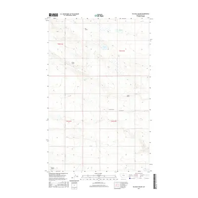
2017 Map of Hilldale Colony
USGS Topo · Published 2017About this map
Hilldale Colony sits at the center of this rural Hill County landscape, representing a modern chapter of communal agricultural settlement in the Montana plains. The terrain is defined by a network of drainage channels including Dog Coulee and Willow Coulee in the north, and Staton Coulee to the east, illustrating how seasonal water runoff has sculpted the local topography. Water management is evident through the presence of McLean Reservoir and Grassy Lake, which are vital for the region's ranching and farming operations. The area is intersected by a grid of secondary routes like Cottonwood Rd and Rd 140 N, along with the north-south alignment of Amos Trl, which together provide the primary infrastructure for this sparsely populated prairie country.
Find a feature on this map
14 named features on this map. Tap any name to fly to it.
Don’t see what you’re looking for? This feature index may not catch every label — zoom into the map to look around manually.
Map Details
Editions of this 2017 Hilldale Colony Map
This is the sole edition of this map. No revisions or reprints were ever made.
Other maps of this area

1904 · Havre
USGS Topo · 1:62,500

1904 · Assinniboine
USGS Topo · 1:62,500

1912 · Thibedeau Lake
USGS Topo · 1:125,000

1953 · Havre
USGS Topo · 1:250,000

1957 · Havre
USGS Topo · 1:250,000

1958 · Havre
USGS Topo · 1:250,000

1964 · Havre NW
USGS Topo · 1:24,000
1970 · Quigley Coulee
USGS Topo · 1:24,000
1970 · Kiehns Coulee
USGS Topo · 1:24,000

1972 · Hilldale Colony
USGS Topo · 1:24,000