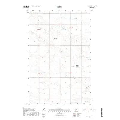
2020 Map of Hilldale Colony
USGS Topo · Published 2020About this map
Hilldale Colony stands as the primary settlement in this northern Montana landscape, located along Cottonwood Rd near the breaks of Staton Coulee. The terrain is defined by its drainage patterns, with significant water features like the McLean Reservoir and Grassy Lake providing essential catchments in this high-plains environment. Navigation across the township lines is facilitated by local tracks such as Amos Trl and Rd 140 N. The map illustrates a specialized agricultural community within Hill County, where the topography is deeply etched by numerous seasonal watercourses, including Willow Coulee and Dog Coulee. These features highlight the importance of water management and topography in the settlement patterns of the Hi-Line region.
Find a feature on this map
13 named features on this map. Tap any name to fly to it.
Don’t see what you’re looking for? This feature index may not catch every label — zoom into the map to look around manually.
Map Details
Editions of this 2020 Hilldale Colony Map
This is the sole edition of this map. No revisions or reprints were ever made.
Other maps of this area

1904 · Havre
USGS Topo · 1:62,500

1904 · Assinniboine
USGS Topo · 1:62,500

1912 · Thibedeau Lake
USGS Topo · 1:125,000

1953 · Havre
USGS Topo · 1:250,000

1957 · Havre
USGS Topo · 1:250,000

1958 · Havre
USGS Topo · 1:250,000

1964 · Havre NW
USGS Topo · 1:24,000
1970 · Quigley Coulee
USGS Topo · 1:24,000
1970 · Kiehns Coulee
USGS Topo · 1:24,000

1972 · Hilldale Colony
USGS Topo · 1:24,000