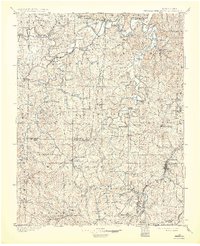
1901 Map of Hillsboro
USGS Topo · Published 1931About this map
De Soto and Hillsboro anchor this turn-of-the-century landscape where the industrial and agrarian economies of Missouri meet. The terrain is defined by the winding paths of the Missouri River, Meramec River, and Big River, each lined with numerous crossings such as Big Eddy Ford and Virginia Mines Ford. The presence of the Vulcan Mine and multiple lumber and flour operations like Pohlman Mill and Waits Sawmill reflects a period of intensive resource extraction and processing. Significant railroad infrastructure, including the St. Louis Iron Mountain and Southern R. R. and the Bonne Terre R. R., links these remote settlements to larger markets. Small communities such as Richwoods, Morse Mill, and House Springs are scattered throughout the region, illustrating the early settlement patterns of Franklin and Jefferson counties.
Find a feature on this map
112 named features on this map. Tap any name to fly to it.
Don’t see what you’re looking for? This feature index may not catch every label — zoom into the map to look around manually.
Map Details
Editions of this 1901 Hillsboro Map
5 editions found
Other maps of this area

1890 · Hermann
USGS Topo · 1:125,000

1901 · De Soto
USGS Topo · 1:125,000

1903 · O'Fallon
USGS Topo · 1:125,000

1903 · Sullivan
USGS Topo · 1:125,000

1904 · Farmington
USGS Topo · 1:62,500

1905 · Bonneterre
USGS Topo · 1:62,500

1906 · Potosi
USGS Topo · 1:62,500

1906 · Farmington
USGS Topo · 1:62,500

1912 · Kimmswick
USGS Topo · 1:62,500

1915 · Crystal City
USGS Topo · 1:62,500