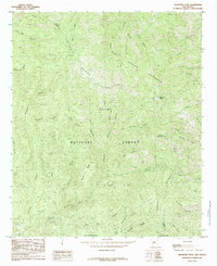
1985 Map of Hillsboro Peak
USGS Topo · Published 1985About this map
Hillsboro Peak dominates this section of the Black Range along the boundary of Grant and Sierra Counties. The landscape is defined by the protected lands of the Gila National Forest and the Aldo Leopold Wilderness, where drainage systems like Gallinas Canyon and North Percha Creek carve deep into the terrain. This 1985 provisional survey captures a transitional moment for the region, documenting a network of pack trails and unimproved roads that provided access for late 20th-century exploration and land management before more modern infrastructure emerged.
Find a feature on this map
43 named features on this map. Tap any name to fly to it.
Don’t see what you’re looking for? This feature index may not catch every label — zoom into the map to look around manually.
Map Details
Editions of this 1985 Hillsboro Peak Map
2 editions found
Other maps of this area

1935 · Hillsboro
USGS Topo · 1:48,000

1940 · Hillsboro
USGS Topo · 1:62,500

1954 · Tularosa
USGS Topo · 1:250,000

1955 · Las Cruces
USGS Topo · 1:250,000

1956 · San Lorenzo
USGS Topo · 1:62,500

1958 · Las Cruces
USGS Topo · 1:250,000

1958 · Tularosa
USGS Topo · 1:250,000
1963 · Hay Mesa
USGS Topo · 1:24,000

1963 · Victoria Park
USGS Topo · 1:24,000

1963 · Apache Peak
USGS Topo · 1:24,000