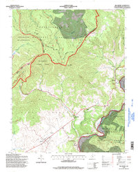
1995 Map of Hillsboro
USGS Topo · Published 1998About this map
The Pearl S Buck Birthplace serves as a prominent cultural landmark on the Little Levels, an area of relatively flat limestone terrain that contrasts sharply with the surrounding ridges of the Allegheny Mountains. This mid-1990s landscape is defined by the transition from the agricultural valley floor near Hillsboro to the dense forests of the Monongahela National Forest. The Greenbrier River carves through the eastern portion of the map, supporting small settlements like Seebert and Buckeye. To the west, the Cranberry Wilderness and the Highland Scenic Highway trace the high elevations of Black Mountain and Yew Mountain. Local spiritual life is anchored by Marvin Chapel and Advent Ch, while the presence of a Quarry and a Drive-in Theater reflects the varied land use in this pocket of Pocahontas County.
Find a feature on this map
54 named features on this map. Tap any name to fly to it.
Don’t see what you’re looking for? This feature index may not catch every label — zoom into the map to look around manually.
Map Details
Editions of this 1995 Hillsboro Map
This is the sole edition of this map. No revisions or reprints were ever made.
Other maps of this area

1891 · Huntersville
USGS Topo · 1:125,000

1894 · Huntersville
USGS Topo · 1:125,000

1915 · Webster Springs
USGS Topo · 1:48,000

1918 · Webster Springs
USGS Topo · 1:62,500

1923 · Lobelia
USGS Topo · 1:48,000

1923 · Marlinton
USGS Topo · 1:48,000

1923 · Mingo
USGS Topo · 1:48,000

1925 · Mingo
USGS Topo · 1:62,500

1925 · Marlinton
USGS Topo · 1:62,500

1925 · Lobelia
USGS Topo · 1:62,500