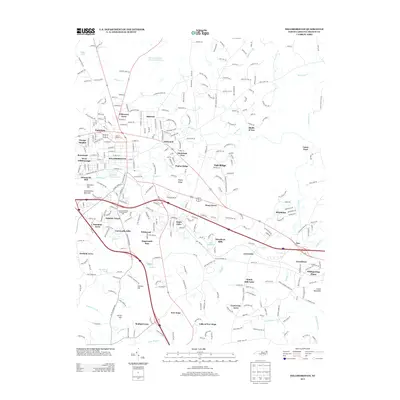
2013 Map of Hillsborough
USGS Topo · Published 2013About this map
Hillsborough sits at the heart of this Orange County landscape, where the Eno River winds past West Hillsborough and the prominent heights of Occoneechee Mountain. The town's historical industrial footprint is marked by Dimmocks Mill and Piedmont Minerals Lake, reflecting the region's connection to natural resources and river-based development. To the south and east, residential expansion is evident in numerous named subdivisions like Cornwallis Hills, Stagecoach Run, and Sunshine Acres, while more rural reaches maintain landmarks such as Windy Hill Farm and the County Subsidiary Prison Number 056. The northern part of the quadrangle is dominated by water infrastructure including the Infinity Rd Raw Water Reservoir and the drainage of Strouds Cr. This document provides a clear look at the intersection of local history and modern suburban growth, documenting the evolution of a central North Carolina community as it stood in the early 21st century.
Find a feature on this map
307 named features on this map. Tap any name to fly to it.
Don’t see what you’re looking for? This feature index may not catch every label — zoom into the map to look around manually.
Map Details
Editions of this 2013 Hillsborough Map
This is the sole edition of this map. No revisions or reprints were ever made.
Other maps of this area

1943 · Durham South
USGS Topo · 1:62,500

1946 · Chapel Hill
USGS Topo · 1:24,000

1947 · Chapel Hill
USGS Topo · 1:31,680

1951 · Durham South
USGS Topo · 1:62,500

1951 · Durham North
USGS Topo · 1:62,500

1953 · Raleigh
USGS Topo · 1:250,000

1953 · Greensboro
USGS Topo · 1:250,000

1954 · Greensboro
USGS Topo · 1:250,000

1954 · Raleigh
USGS Topo · 1:250,000

1962 · Greensboro
USGS Topo · 1:250,000