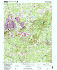
1997 Map of Hillsborough
USGS Topo · Published 1999About this map
The Governor Burke Grave sits just north of the Eno River in this late-twentieth-century study of the Piedmont landscape. The area is defined by the historic town of Hillsborough and its westward expansion into West Hillsborough and Fairview, where the Norfolk and Western rail lines intersect with local industry and civic life. The terrain is notably marked by significant elevations like Occoneechee Mtn and Mountain Ridge, which overlook the winding river corridor now protected within the Eno River State Park.
Find a feature on this map
53 named features on this map. Tap any name to fly to it.
Don’t see what you’re looking for? This feature index may not catch every label — zoom into the map to look around manually.
Map Details
Editions of this 1997 Hillsborough Map
This is the sole edition of this map. No revisions or reprints were ever made.
Other maps of this area

1943 · Durham South
USGS Topo · 1:62,500

1946 · Chapel Hill
USGS Topo · 1:24,000

1947 · Chapel Hill
USGS Topo · 1:31,680

1951 · Durham South
USGS Topo · 1:62,500

1951 · Durham North
USGS Topo · 1:62,500

1953 · Raleigh
USGS Topo · 1:250,000

1953 · Greensboro
USGS Topo · 1:250,000

1954 · Greensboro
USGS Topo · 1:250,000

1954 · Raleigh
USGS Topo · 1:250,000

1962 · Greensboro
USGS Topo · 1:250,000