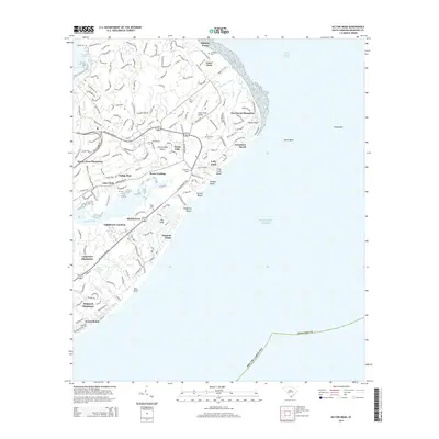
2014 Map of Hilton Head
USGS Topo · Published 2014About this map
Honey Horn Plantation and Shipyard Plantation anchor the landscape of this coastal barrier island, illustrating a modern geography deeply rooted in historical land divisions. The map reveals the intricate development of Hilton Head Island as it appeared in the early 21st century, where residential and resort communities like Palmetto Dunes and Indigo Run interface with the surrounding salt marshes and waterways. Cultural history is preserved in small pockets throughout the island, marked by several local burial grounds including Pope Cem, Drayton Cem, and the historic Baynard Tomb. Transportation and maritime safety features such as the Hilton Head Airport and the Hilton Head Rear Range indicate the island's dual role as a high-end destination and a significant waypoint along the Intracoastal Waterway. This detailed survey traces the complex network of private drives and public roads that replaced the island's once-isolated agricultural tracts.
Find a feature on this map
44 named features on this map. Tap any name to fly to it.
Don’t see what you’re looking for? This feature index may not catch every label — zoom into the map to look around manually.
Map Details
Editions of this 2014 Hilton Head Map
This is the sole edition of this map. No revisions or reprints were ever made.
Other maps of this area

1920 · Okatie
USGS Topo · 1:62,500

1920 · Hilton Head
USGS Topo · 1:62,500

1920 · Bluffton
USGS Topo · 1:62,500

1942 · Okatie
USGS Topo · 1:62,500

1944 · Fort Fremont
USGS Topo · 1:62,500

1945 · Bluffton
USGS Topo · 1:62,500

1945 · Hilton Head
USGS Topo · 1:62,500

1947 · Savannah
USGS Topo · 1:250,000

1948 · Savannah
USGS Topo · 1:250,000
1955 · Savannah Beach North
USGS Topo · 1:24,000
Featured Places
- Hilton Head Island, SC
- Palmetto Dunes, Hilton Head Island
- Port Royal, Hilton Head Island
- Hilton Head Plantation, Hilton Head Island
- Indigo Run, Hilton Head Island