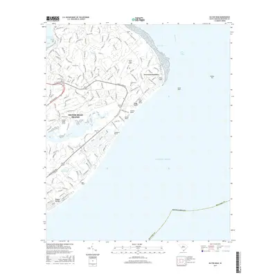
2017 Map of Hilton Head
USGS Topo · Published 2017About this map
Hilton Head Island presents a highly developed coastal landscape where residential plantations and public beaches meet the tidal marshes of Skull Cr and Broad Cr. This modern survey highlights a complex network of named roads and lanes, including William Hilton Pkwy, that weave through established communities such as Port Royal Plantation and Forest Beach. Local heritage is preserved in a series of small, scattered burial grounds like Talbor Cem, Drayton Cem, and Government Cem, offering significant data for genealogical research on the island. The maritime and aviation character of the region is anchored by the Hilton Head Airport and the Hilton Head Rear Range light. Along the Atlantic coast, prominent features such as Joiner Bank and Fishing Rip define the offshore topography near the entrance to Port Royal Sound.
Find a feature on this map
153 named features on this map. Tap any name to fly to it.
Don’t see what you’re looking for? This feature index may not catch every label — zoom into the map to look around manually.
Map Details
Editions of this 2017 Hilton Head Map
This is the sole edition of this map. No revisions or reprints were ever made.
Other maps of this area

1920 · Okatie
USGS Topo · 1:62,500

1920 · Hilton Head
USGS Topo · 1:62,500

1920 · Bluffton
USGS Topo · 1:62,500

1942 · Okatie
USGS Topo · 1:62,500

1944 · Fort Fremont
USGS Topo · 1:62,500

1945 · Bluffton
USGS Topo · 1:62,500

1945 · Hilton Head
USGS Topo · 1:62,500

1947 · Savannah
USGS Topo · 1:250,000

1948 · Savannah
USGS Topo · 1:250,000
1955 · Savannah Beach North
USGS Topo · 1:24,000
Featured Places
- Hilton Head Island, SC
- Palmetto Dunes, Hilton Head Island
- Port Royal, Hilton Head Island
- Hilton Head Plantation, Hilton Head Island
- Indigo Run, Hilton Head Island