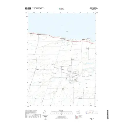
2019 Map of Hilton
USGS Topo · Published 2019About this map
Lake Ontario defines the northern landscape of this Monroe County coastal region, where beach communities such as Benedict Beach, Shore Acres, and Wautoma Beach line the shore. Inland, the village of Hilton serves as the central hub, surrounded by smaller historical settlements like Walker, Collamer, and Parma Center. The map reveals a land structured by agricultural roots and lineage, evidenced by a high density of small family burial grounds including Hendershot Pioneer Cem, Smith Family Pioneer Cem, and Atchinson Family Pioneer Cem. Regional transportation is anchored by the Lake Ontario State Pkwy and the legacy of the Old Hojack Rd, while local aviation is represented by the Hendershot Airport. The terrain is characterized by a network of north-flowing waterways, most notably Salmon Creek and Otis Creek, which drain into the shoals of the great lake.
Find a feature on this map
95 named features on this map. Tap any name to fly to it.
Don’t see what you’re looking for? This feature index may not catch every label — zoom into the map to look around manually.
Map Details
Editions of this 2019 Hilton Map
This is the sole edition of this map. No revisions or reprints were ever made.
Other maps of this area

1895 · Rochester
USGS Topo · 1:62,500

1895 · Ontario Beach
USGS Topo · 1:62,500

1898 · Rochester
USGS Topo · 1:62,500

1899 · Hamlin
USGS Topo · 1:62,500

1899 · Ontario Beach
USGS Topo · 1:62,500

1899 · Brockport
USGS Topo · 1:62,500

1912 · Rochester
USGS Topo · 1:62,500

1912 · Ontario Beach
USGS Topo · 1:62,500

1920 · Rochester
USGS Topo · 1:62,500

1931 · Rochester West
USGS Topo · 1:24,000