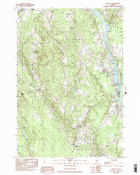
1982 Map of Hinckley
USGS Topo · Published 1982About this map
The Kennebec River carves a deep valley through this Maine landscape, serving as the boundary between Somerset and Kennebec counties. Along its western bank, the Maine Central Railroad tracks parallel the water, connecting the riverfront settlement of Hinckley to the surrounding timber and agricultural lands. To the west, the terrain rises into prominent elevations such as Bigelow Hill, Little Bear Mtn, and Bear Mtn, while the rural interior is dotted with small crossroads like Larone and Holway Corner. This 1982 provisional edition details the mid-century infrastructure of the region, including local landmarks like the Hinckley Home Farm Sch and several family burial grounds such as Covell Cem and Friend Cem. The map reveals a land defined by its drainages, where Martin Stream and Snow Brook feed into the Kennebec, and local industry is represented by scattered Gravel Pits.
Find a feature on this map
34 named features on this map. Tap any name to fly to it.
Don’t see what you’re looking for? This feature index may not catch every label — zoom into the map to look around manually.
Map Details
Editions of this 1982 Hinckley Map
This is the sole edition of this map. No revisions or reprints were ever made.
Other maps of this area

1892 · Waterville
USGS Topo · 1:62,500

1894 · Norridgewock
USGS Topo · 1:62,500

1898 · Norridgewock
USGS Topo · 1:62,500

1904 · Anson
USGS Topo · 1:62,500

1913 · Skowhegan
USGS Topo · 1:62,500

1943 · Norridgewock
USGS Topo · 1:62,500

1943 · Waterville
USGS Topo · 1:62,500

1948 · Bangor
USGS Topo · 1:250,000

1955 · Anson
USGS Topo · 1:62,500

1955 · Skowhegan
USGS Topo · 1:62,500