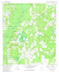
1982 Map of Hinsons Crossroads
USGS Topo · Published 1982About this map
The Choctawhatchee River and its intricate network of sloughs and cutoffs dominate the northern landscape of this Florida panhandle quadrangle. Historically significant landings such as Billy Lee Landing and Gum Creek Landing underscore the river's importance to local transit and commerce. The interior is marked by numerous family-named clearings and fields, including Cooey Field, Thomas Field, and Connely Field, reflecting a pattern of rural settlement where agriculture and timber harvesting shaped the land.
Find a feature on this map
81 named features on this map. Tap any name to fly to it.
Don’t see what you’re looking for? This feature index may not catch every label — zoom into the map to look around manually.
Map Details
Editions of this 1982 Hinsons Crossroads Map
This is the sole edition of this map. No revisions or reprints were ever made.
Other maps of this area

1948 · Ponce De Leon
USGS Topo · 1:24,000

1949 · Millers Ferry
USGS Topo · 1:24,000

1949 · Redbay
USGS Topo · 1:24,000

1949 · Hinsons Cross Roads
USGS Topo · 1:24,000

1949 · Caryville
USGS Topo · 1:24,000

1950 · Prosperity
USGS Topo · 1:24,000

1950 · Millers Ferry
USGS Topo · 1:24,000

1950 · Ponce De Leon
USGS Topo · 1:24,000

1950 · Hinsons Cross Roads
USGS Topo · 1:24,000

1950 · Redbay
USGS Topo · 1:24,000