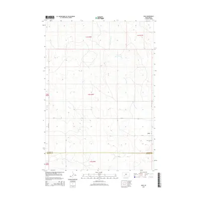
2015 Map of Hisle
USGS Topo · Published 2015About this map
The settlement of Hisle serves as a focal point in this 2015 survey of the South Dakota landscape where the Jackson Co Bennett Co boundary line divides the plains. Just southeast of the town site, Saint Joseph Cem remains a significant landmark for those tracing local family roots. The terrain is defined by the winding paths of Corn Cr and the more prominent Bear-in-the-Lodge Cr, which flows northward through the eastern portion of the quadrangle. Local transportation is represented by a grid of rural roads, including Snake Butte Rd and 275th St. This survey captures the sparse, high-plains settlement pattern where large ranching sections are intersected by narrow creeks and long-stretching county roads like Hisle Rd, illustrating the enduring agricultural character of the region.
Find a feature on this map
18 named features on this map. Tap any name to fly to it.
Don’t see what you’re looking for? This feature index may not catch every label — zoom into the map to look around manually.
Map Details
Editions of this 2015 Hisle Map
This is the sole edition of this map. No revisions or reprints were ever made.
Other maps of this area

1950 · Interior SE
USGS Topo · 1:24,000

1950 · Potato Creek
USGS Topo · 1:24,000

1950 · Wanblee
USGS Topo · 1:24,000

1955 · Martin
USGS Topo · 1:250,000

1958 · Martin
USGS Topo · 1:250,000

1980 · Kadoka
USGS Topo · 1:100,000

1981 · Patricia
USGS Topo · 1:25,000

1981 · Allen
USGS Topo · 1:25,000

1981 · Hisle
USGS Topo · 1:25,000
1981 · Buzzard Butte
USGS Topo · 1:25,000