
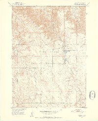
1950 Map of Wanblee
USGS Topo · Published 1952About this map
Pine Ridge Indian Reservation lands dominate this mid-century survey, centered on the settlement of Wanblee. The landscape is defined by the drainage patterns of Eagle Nest Creek and Craven Creek, where the transition from higher plateau to creek bed is marked by detailed topographic contours. The community layout in Wanblee is documented alongside critical local institutions including Gethsemane Cem and St Ignatius Cem. Farther south, the Eagle Nest Sch stands as a primary landmark in a region otherwise characterized by isolated homesteads and open rangeland. This 1950 field check captures the area during the Department of the Interior program for the development of the Missouri River Basin, providing a snapshot of the infrastructure and land use in this part of South Dakota before later modernizations.
Find a feature on this map
7 named features on this map. Tap any name to fly to it.
Don’t see what you’re looking for? This feature index may not catch every label — zoom into the map to look around manually.
Map Details
Editions of this 1950 Wanblee Map
3 editions found
Other maps of this area

1950 · Interior SE
USGS Topo · 1:24,000

1951 · Wanblee NW
USGS Topo · 1:24,000

1951 · School Section Butte
USGS Topo · 1:24,000

1951 · Wanblee NE
USGS Topo · 1:24,000

1955 · Martin
USGS Topo · 1:250,000

1958 · Martin
USGS Topo · 1:250,000

1980 · Kadoka
USGS Topo · 1:100,000

1981 · Broken Leg Dam
USGS Topo · 1:24,000

1981 · Hisle
USGS Topo · 1:25,000
1981 · Buzzard Butte
USGS Topo · 1:25,000