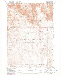
1950 Map of Wanblee
USGS Topo · Published 1979About this map
The community of Wanblee is the focal point of this survey, located within the vast northern expanses of the Pine Ridge Indian Reservation. This 1950 mapping, later updated with photorevisions, reveals the specific landscape of the Washabaugh County area before later administrative changes. The settlement pattern is defined by the drainage basins of Eagle Nest Creek and Craven Creek, which carve through the high plains. Local genealogy is anchored by the presence of Gethsemane Cem and St Ignatius Cem, while a Spillway 2642 suggests early water management efforts in this part of the Missouri River Basin development. The terrain is marked by the sharp contrast between the flat upland plains and the complex, eroded draws leading down toward Long Creek in the northeast.
Find a feature on this map
9 named features on this map. Tap any name to fly to it.
Don’t see what you’re looking for? This feature index may not catch every label — zoom into the map to look around manually.
Map Details
Editions of this 1950 Wanblee Map
3 editions found
Other maps of this area

1950 · Interior SE
USGS Topo · 1:24,000

1950 · Wanblee
USGS Topo · 1:24,000

1951 · Wanblee NW
USGS Topo · 1:24,000

1951 · School Section Butte
USGS Topo · 1:24,000

1951 · Wanblee NE
USGS Topo · 1:24,000

1955 · Martin
USGS Topo · 1:250,000

1958 · Martin
USGS Topo · 1:250,000

1980 · Kadoka
USGS Topo · 1:100,000

1981 · Broken Leg Dam
USGS Topo · 1:24,000

1981 · Hisle
USGS Topo · 1:25,000