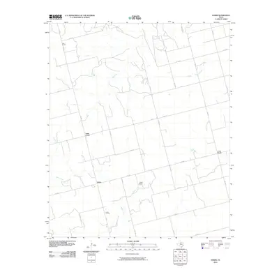
2010 Map of Hobbs
USGS Topo · Published 2010About this map
Hobbs and its surrounding countryside are defined by a network of drainage ways and ranch roads in this rural portion of Fisher County. The landscape is subtly marked by low-lying features like Coon Hollow and the meandering path of the Clear Fork, which is joined by tributaries such as Buffalo Creek and Spring Creek. Small community centers and rural intersections like Scotts Corner and Cross Roads indicate the dispersed nature of settlement here, while the Hobbs Cemetery and Grady Cemetery serve as lasting markers of local family history and genealogy. The map captures a high level of detail for the local road system, including Farm to Market roads like FM 611 and FM 1657, which connect the remote ranches and former agricultural hubs of the region.
Find a feature on this map
37 named features on this map. Tap any name to fly to it.
Don’t see what you’re looking for? This feature index may not catch every label — zoom into the map to look around manually.
Map Details
Editions of this 2010 Hobbs Map
This is the sole edition of this map. No revisions or reprints were ever made.
Other maps of this area

1893 · Roby
USGS Topo · 1:125,000

1926 · Snyder 1-a
USGS Topo · 1:48,000

1926 · Roby 2-b
USGS Topo · 1:48,000

1931 · Rotan
USGS Topo · 1:62,500

1932 · Camp Springs
USGS Topo · 1:62,500

1954 · Big Spring
USGS Topo · 1:250,000

1958 · Big Spring
USGS Topo · 1:250,000
1969 · White Canyon
USGS Topo · 1:24,000

1969 · Camp Springs
USGS Topo · 1:24,000

1969 · Rotan
USGS Topo · 1:24,000