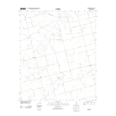
2012 Map of Hobbs
USGS Topo · Published 2012About this map
Hobbs and the surrounding ranchlands of Fisher County are defined by a network of drainage creeks and rural crossroads in this 2012 study. The landscape is structured around the Clear Fork of the Brazos River system, with local waterways like Spring Cr, Red Cr, and Hackberry Cr carving paths through the terrain. A clear pattern of early 21st-century rural infrastructure is visible, with Farm-To-Market Road 611 W serving as a primary artery connecting localized centers such as Scotts Corner and Cross Roads. Genealogists and local historians will find significant value in the documentation of the Hobbs Cem and Grady Cem, alongside unique land holdings like the Duu Bu Mariah Rwl Rnch. The map also identifies local landmarks such as Coon Hollow, reflecting the distinct topography of this part of West Texas.
Find a feature on this map
41 named features on this map. Tap any name to fly to it.
Don’t see what you’re looking for? This feature index may not catch every label — zoom into the map to look around manually.
Map Details
Editions of this 2012 Hobbs Map
This is the sole edition of this map. No revisions or reprints were ever made.
Other maps of this area

1893 · Roby
USGS Topo · 1:125,000

1926 · Snyder 1-a
USGS Topo · 1:48,000

1926 · Roby 2-b
USGS Topo · 1:48,000

1931 · Rotan
USGS Topo · 1:62,500

1932 · Camp Springs
USGS Topo · 1:62,500

1954 · Big Spring
USGS Topo · 1:250,000

1958 · Big Spring
USGS Topo · 1:250,000
1969 · White Canyon
USGS Topo · 1:24,000

1969 · Camp Springs
USGS Topo · 1:24,000

1969 · Rotan
USGS Topo · 1:24,000