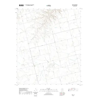
2019 Map of Hobbs
USGS Topo · Published 2019About this map
The Hobbs community in Fisher County sits within a landscape defined by the drainage network of the Clear Fork Brazos River. This 2019 survey captures the rural character of the region, where family history is anchored at the Hobbs Cem and Grady Cem. The terrain transitions from the winding riverbed to the breaks of Coon Hollow and the upland reaches of the Duu Bu Mariag Rwl Ranch. A network of farm-to-market roads, including FM 611 and FM 1614, connects these scattered landmarks across a territory shaped by numerous seasonal waterways like Spring Cr, Red Cr, and Buffalo Cr. The map details a modern ranching and agricultural landscape that maintains the footprint of its earlier settlement period.
Find a feature on this map
37 named features on this map. Tap any name to fly to it.
Don’t see what you’re looking for? This feature index may not catch every label — zoom into the map to look around manually.
Map Details
Editions of this 2019 Hobbs Map
This is the sole edition of this map. No revisions or reprints were ever made.
Other maps of this area

1893 · Roby
USGS Topo · 1:125,000

1926 · Snyder 1-a
USGS Topo · 1:48,000

1926 · Roby 2-b
USGS Topo · 1:48,000

1931 · Rotan
USGS Topo · 1:62,500

1932 · Camp Springs
USGS Topo · 1:62,500

1954 · Big Spring
USGS Topo · 1:250,000

1958 · Big Spring
USGS Topo · 1:250,000
1969 · White Canyon
USGS Topo · 1:24,000

1969 · Camp Springs
USGS Topo · 1:24,000

1969 · Rotan
USGS Topo · 1:24,000