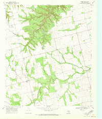
1969 Map of Hobbs
USGS Topo · Published 1972About this map
Clear Fork Brazos River winds through the southern portion of this landscape, its path shadowed by a modern pipeline and an aqueduct that reflect the mid-century infrastructure of Fisher County. The rural character of the late 1960s is defined by small, isolated landmarks such as Scotts Corner and Cross Roads, which anchor a network of light-duty roads. For those tracing family ties to the area, the map preserves the locations of Hobbs Cem and Grady Cem, alongside small local airstrips like Phillips Landing Field. The drainage patterns of Hackberry Creek and Spring Creek dissect the terrain, punctuated by occasional oil wells and a Gravel Pit, indicating the local extraction economy during this era.
Find a feature on this map
16 named features on this map. Tap any name to fly to it.
Don’t see what you’re looking for? This feature index may not catch every label — zoom into the map to look around manually.
Map Details
Editions of this 1969 Hobbs Map
This is the sole edition of this map. No revisions or reprints were ever made.
Other maps of this area

1893 · Roby
USGS Topo · 1:125,000

1926 · Snyder 1-a
USGS Topo · 1:48,000

1926 · Roby 2-b
USGS Topo · 1:48,000

1931 · Rotan
USGS Topo · 1:62,500

1932 · Camp Springs
USGS Topo · 1:62,500

1954 · Big Spring
USGS Topo · 1:250,000

1958 · Big Spring
USGS Topo · 1:250,000
1969 · White Canyon
USGS Topo · 1:24,000

1969 · Camp Springs
USGS Topo · 1:24,000

1969 · Rotan
USGS Topo · 1:24,000