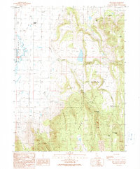
1990 Map of Hog Valley
USGS Topo · Published 1990About this map
Modoc National Forest dominates the eastern high ground of this Lassen County landscape, where the transition from the irrigated ranching of Big Valley to the wooded uplands of Hog Valley is sharply defined. Water management is the primary human footprint here, visible in the extensive network of irrigation infrastructure such as Babcock Ditch and the Gaging Station located along the seasonal watercourses. The presence of Ditch Camp and the Hog Valley Reservoir underscores the long-standing efforts to harness the runoff from the high ridges for valley agriculture.
Find a feature on this map
21 named features on this map. Tap any name to fly to it.
Don’t see what you’re looking for? This feature index may not catch every label — zoom into the map to look around manually.
Map Details
Editions of this 1990 Hog Valley Map
This is the sole edition of this map. No revisions or reprints were ever made.
Other maps of this area

1886 · Alturas
USGS Topo · 1:250,000

1886 · Honey Lake
USGS Topo · 1:250,000

1886 · Lassen Peak
USGS Topo · 1:250,000

1886 · Modoc Lava Bed
USGS Topo · 1:250,000

1891 · Honey Lake
USGS Topo · 1:250,000

1892 · Modoc Lava-Bed
USGS Topo · 1:250,000

1892 · Lassen Peak
USGS Topo · 1:250,000

1892 · Alturas
USGS Topo · 1:250,000

1893 · Honey Lake
USGS Topo · 1:250,000

1894 · Lassen Peak
USGS Topo · 1:250,000