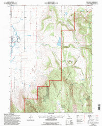
1993 Map of Hog Valley
USGS Topo · Published 1997About this map
The transition from the irrigated valley floors to the higher timberlands of the Modoc National Forest defines this part of Lassen County. In the west, the Big Valley River and its accompanying Slough are managed through an extensive network of infrastructure, including levee systems, the Babcock Ditch, and a Gaging Station. This water management supported the small settlement at Pumpkin Center and surrounding agricultural lands before the terrain rises sharply toward the east.
Find a feature on this map
22 named features on this map. Tap any name to fly to it.
Don’t see what you’re looking for? This feature index may not catch every label — zoom into the map to look around manually.
Map Details
Editions of this 1993 Hog Valley Map
This is the sole edition of this map. No revisions or reprints were ever made.
Other maps of this area

1886 · Alturas
USGS Topo · 1:250,000

1886 · Honey Lake
USGS Topo · 1:250,000

1886 · Lassen Peak
USGS Topo · 1:250,000

1886 · Modoc Lava Bed
USGS Topo · 1:250,000

1891 · Honey Lake
USGS Topo · 1:250,000

1892 · Modoc Lava-Bed
USGS Topo · 1:250,000

1892 · Lassen Peak
USGS Topo · 1:250,000

1892 · Alturas
USGS Topo · 1:250,000

1893 · Honey Lake
USGS Topo · 1:250,000

1894 · Lassen Peak
USGS Topo · 1:250,000