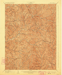
1906 Map of Holbrook
USGS Topo · Published 1923About this map
Auburn and Coxs Mills serve as central nodes for the dissected plateau of central West Virginia during the early 1900s. The landscape is defined by the winding drainages of the South Fork Hughes River and the North Fork Hughes River, where small settlements like Holbrook and Summers were established at critical stream junctions. The map documents the historic transport artery of the Parkersburg and Staunton Pike as it cuts through the southern portion of the quadrangle near Burnt House, illustrating how early overland routes followed the contours of the ridge-and-valley topography. Numerous family-named landmarks and runs, such as Pritchard Run, Hardmans Fork, and Jessie Run, reveal a pattern of rural homesteading and local industry before the widespread development of the modern highway system. This 1903-1904 survey also clearly delineates the boundaries where Ritchie, Gilmer, and Doddridge counties meet.
Find a feature on this map
73 named features on this map. Tap any name to fly to it.
Don’t see what you’re looking for? This feature index may not catch every label — zoom into the map to look around manually.
Map Details
Editions of this 1906 Holbrook Map
2 editions found
Other maps of this area

1893 · Sutton
USGS Topo · 1:125,000

1904 · Vadis
USGS Topo · 1:62,500

1905 · Centerpoint
USGS Topo · 1:62,500

1905 · West Union
USGS Topo · 1:62,500

1906 · Saint Marys
USGS Topo · 1:62,500

1906 · Holbrook
USGS Topo · 1:62,500

1906 · Glenville
USGS Topo · 1:62,500

1906 · Burnsville
USGS Topo · 1:62,500

1907 · Harrisville
USGS Topo · 1:62,500

1907 · Arnoldsburg
USGS Topo · 1:62,500