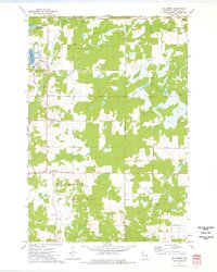
1973 Map of Holcombe
USGS Topo · Published 1976About this map
Lake Holcombe and the Holcombe Flowage dominate the northwestern corner of this 1973 study, where the Chippewa River meets the Fisher River. The landscape reveals a transition from these significant water bodies to the heavily forested and swampy tracts of the Ruby, Estella, and Colburn townships. Transport history is etched into the terrain by an Old Railroad Grade that cuts across the north, bypassing the small settlement of Arnold.
Find a feature on this map
31 named features on this map. Tap any name to fly to it.
Don’t see what you’re looking for? This feature index may not catch every label — zoom into the map to look around manually.
Map Details
Editions of this 1973 Holcombe Map
This is the sole edition of this map. No revisions or reprints were ever made.
Other maps of this area

1947 · Sheldon
USGS Topo · 1:48,000

1948 · Ladysmith
USGS Topo · 1:48,000

1949 · Sheldon
USGS Topo · 1:48,000

1950 · Ladysmith
USGS Topo · 1:48,000

1951 · Cornell
USGS Topo · 1:62,500

1951 · Gilman
USGS Topo · 1:62,500

1953 · Rice Lake
USGS Topo · 1:250,000

1959 · Rice Lake
USGS Topo · 1:250,000
1971 · Ladysmith SE
USGS Topo · 1:24,000
1971 · Sheldon
USGS Topo · 1:24,000