1947 Map of Sheldon
USGS Topo · Published 1967About this map
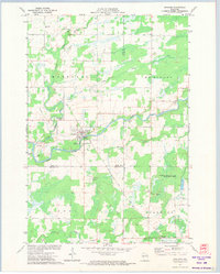
The Jump River meanders through the heart of this landscape, anchoring a rural Wisconsin territory defined by small settlements and a dense network of country schoolhouses during the late 1940s. The village of Sheldon serves as a primary hub, while the Minneapolis St Paul and Sault Ste Marie railway lines connect the northern settlements of Tony, Glen Flora, and Ingram. This era of development shows a heavy reliance on local community centers, evidenced by the numerous named schools such as Baughman Sch, Pioneer Sch, and Sunnyside Sch that dot the townships of Marshall and McKinley.
Find a feature on this map
56 named features on this map. Tap any name to fly to it.
Don’t see what you’re looking for? This feature index may not catch every label — zoom into the map to look around manually.
Map Details
Editions of this 1947 Sheldon Map
This is the sole edition of this map. No revisions or reprints were ever made.
Historical Maps of Ruby Through Time
4 maps found