
1945 Map of Black River
USGS Topo · Published 1945About this map
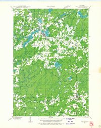
The Jump River and its numerous tributaries dominate this northern Wisconsin landscape during the mid-1940s, revealing a region defined by its complex drainage and forested expanse. Much of the southern portion of this sheet is occupied by the Chequamegon National Forest, while the northern half is divided into the townships of Kennan and Westboro. The map provides a look at the rural educational infrastructure of the era, noting the locations of the Meadow Creek Sch, Riley Sch, and the uniquely named Red Tile Sch.
Find a feature on this map
22 named features on this map. Tap any name to fly to it.
Don’t see what you’re looking for? This feature index may not catch every label — zoom into the map to look around manually.
Map Details
Editions of this 1945 Black River Map
This is the sole edition of this map. No revisions or reprints were ever made.
Other maps of this area

1941 · Kennan
USGS Topo · 1:48,000
1941 · Phillips
USGS Topo · 1:48,000
1943 · Philliips
USGS Topo · 1:48,000

1944 · Ogema
USGS Topo · 1:48,000

1945 · Kennan
USGS Topo · 1:48,000

1945 · Ingram
USGS Topo · 1:48,000

1947 · Ingram
USGS Topo · 1:48,000

1947 · Ogema
USGS Topo · 1:48,000

1947 · Sheldon
USGS Topo · 1:48,000

1949 · Sheldon
USGS Topo · 1:48,000