
1945 Map of Ingram
USGS Topo · Published 1967About this map
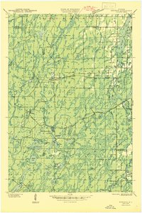
The Flambeau River and its South Fork dominate this 1945 examination of Rusk and Sawyer counties. The landscape is defined by its logging and conservation history, featuring the Flambeau River State Forest and several remote outposts like Weilep Camp and Fink Camp. A notable piece of Depression-era history is recorded at the CCC Rusk Camp (Abandoned) near Big Falls, reflecting the transition from active timber extraction to state-managed forestry.
Find a feature on this map
58 named features on this map. Tap any name to fly to it.
Don’t see what you’re looking for? This feature index may not catch every label — zoom into the map to look around manually.
Map Details
Editions of this 1945 Ingram Map
This is the sole edition of this map. No revisions or reprints were ever made.
Other maps of this area

1941 · Kennan
USGS Topo · 1:48,000

1941 · Kennedy
USGS Topo · 1:48,000

1944 · Exeland
USGS Topo · 1:48,000

1944 · Draper
USGS Topo · 1:48,000

1944 · Radisson
USGS Topo · 1:48,000
1945 · Kennedy
USGS Topo · 1:48,000

1945 · Kennan
USGS Topo · 1:48,000

1945 · Black River
USGS Topo · 1:48,000

1947 · Exeland
USGS Topo · 1:48,000

1947 · Ingram
USGS Topo · 1:48,000