
1947 Map of Ingram
USGS Topo · Published 1947About this map
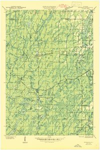
The confluence of the South Fork Flambeau River and several major tributaries defines this Rusk County landscape during the mid-1940s. The river's power is harnessed at the Big Falls Dam & Power Plant, which created the Big Falls Flowage upstream. This era marks a transition in land use, visible in the designated Flambeau River State Forest and the presence of the CCC Rusk Camp (Abandoned), reflecting Depression-era conservation work in the Wisconsin Northwoods. Local infrastructure is anchored by the village of Ingram in the south, served by the Minneapolis Sault Ste Marie and Atlantic RR (Abandoned) line. Fire prevention is a clear priority for the timbered region, evidenced by the Cedar Rapids Fire Tower and Ladd Creek Fire Tower keeping watch over the townships of Winter, Big Falls, and True. Local genealogy is preserved through sites like the Swedish Lutheran Cem and Pioneer Sch.
Find a feature on this map
42 named features on this map. Tap any name to fly to it.
Don’t see what you’re looking for? This feature index may not catch every label — zoom into the map to look around manually.
Map Details
Editions of this 1947 Ingram Map
This is the sole edition of this map. No revisions or reprints were ever made.
Other maps of this area

1941 · Kennan
USGS Topo · 1:48,000

1941 · Kennedy
USGS Topo · 1:48,000

1944 · Exeland
USGS Topo · 1:48,000

1944 · Draper
USGS Topo · 1:48,000

1944 · Radisson
USGS Topo · 1:48,000
1945 · Kennedy
USGS Topo · 1:48,000

1945 · Kennan
USGS Topo · 1:48,000

1945 · Black River
USGS Topo · 1:48,000

1945 · Ingram
USGS Topo · 1:48,000

1947 · Exeland
USGS Topo · 1:48,000