1945 Map of Kennedy
USGS Topo · Published 1945About this map
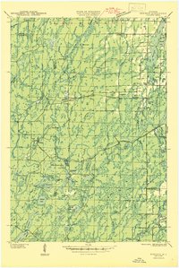
The Northwoods of Wisconsin are depicted here in the early 1940s, a landscape defined by the winding Lake Flambeau and the intense timber and rail activity of the era. The Chicago and Northwestern railroad cuts through the center of the sheet, connecting the small settlements of Kennedy and Kaiser to the wider region. This period shows a transition from the logging heyday toward conservation, with the Chequamegon National Forest and Flambeau River State Forest covering vast tracts of the terrain.
Find a feature on this map
84 named features on this map. Tap any name to fly to it.
Don’t see what you’re looking for? This feature index may not catch every label — zoom into the map to look around manually.
Map Details
Editions of this 1945 Kennedy Map
2 editions found
Historical Maps of Draper Through Time
139 maps found

1941 Brantwood
Price County, WI

1941 Kennedy
Price County, WI

1941 Pike Lake
Price County, WI

1942 Pike Lake
Price County, WI

1943 Brantwood
Price County, WI

1945 Kennedy
Price County, WI

1950 Pike Lake
Price County, WI

1968 Park Falls NE
Price County, WI

1968 Park Falls SE
Price County, WI

1970 Butternut Lake
Price County, WI

1970 Jump River Fire Tower NE
Price County, WI

1970 Lugerville
Price County, WI

1970 Ogema NW
Price County, WI

1971 Lac Sault Dore
Price County, WI

1971 Pike Lake NW
Price County, WI

1971 Pike Lake
Price County, WI

1971 Pike Lake SE
Price County, WI

1971 Pike Lake SW
Price County, WI

1979 Big Briens Lake
Price County, WI

1979 Brantwood
Price County, WI

1979 Dover
Price County, WI

1979 Spirit
Price County, WI

1979 Timms Hill
Price County, WI

1980 Thunder Creek
Price County, WI

1984 Blockhouse Lake
Price County, WI

1984 Cranberry Lake
Price County, WI

1984 Gates Lake
Price County, WI

1984 Pennington
Price County, WI

1984 Priest Lake
Price County, WI

2005 Blockhouse Lake
Price County, WI

2005 Dover
Price County, WI

2005 Gates Lake
Price County, WI

2005 Jump River Fire Tower NE
Price County, WI

2005 Ogema NW
Price County, WI

2005 Pike Lake NW
Price County, WI

2005 Pike Lake
Price County, WI

2005 Pike Lake SE
Price County, WI

2005 Pike Lake SW
Price County, WI

2005 Thunder Creek
Price County, WI

2010 Big Briens Lake
Price County, WI

2010 Brantwood
Price County, WI

2010 Butternut Lake
Price County, WI

2010 Cranberry Lake
Price County, WI

2010 Lac Sault Dore
Price County, WI

2010 Lugerville
Price County, WI

2010 Pennington
Price County, WI

2010 Priest Lake
Price County, WI

2010 Spirit
Price County, WI

2010 Timms Hill
Price County, WI

2011 Blockhouse Lake
Price County, WI

2011 Dover
Price County, WI

2011 Gates Lake
Price County, WI

2011 Jump River Fire Tower NE
Price County, WI

2011 Ogema NW
Price County, WI

2011 Pike Lake NW
Price County, WI

2011 Pike Lake
Price County, WI

2011 Pike Lake SE
Price County, WI

2011 Pike Lake SW
Price County, WI

2011 Thunder Creek
Price County, WI

2013 Big Briens Lake
Price County, WI

2013 Blockhouse Lake
Price County, WI

2013 Brantwood
Price County, WI

2013 Butternut Lake
Price County, WI

2013 Cranberry Lake
Price County, WI

2013 Dover
Price County, WI

2013 Gates Lake
Price County, WI

2013 Jump River Fire Tower NE
Price County, WI

2013 Lac Sault Dore
Price County, WI

2013 Lugerville
Price County, WI

2013 Ogema NW
Price County, WI

2013 Pennington
Price County, WI

2013 Pike Lake NW
Price County, WI

2013 Pike Lake
Price County, WI

2013 Pike Lake SE
Price County, WI

2013 Pike Lake SW
Price County, WI

2013 Priest Lake
Price County, WI

2013 Spirit
Price County, WI

2013 Thunder Creek
Price County, WI

2013 Timms Hill
Price County, WI

2015 Big Briens Lake
Price County, WI

2015 Blockhouse Lake
Price County, WI

2015 Brantwood
Price County, WI

2015 Butternut Lake
Price County, WI

2015 Cranberry Lake
Price County, WI

2015 Dover
Price County, WI

2015 Gates Lake
Price County, WI

2015 Jump River Fire Tower NE
Price County, WI

2015 Lac Sault Dore
Price County, WI

2015 Lugerville
Price County, WI

2015 Ogema NW
Price County, WI

2015 Pennington
Price County, WI

2015 Pike Lake NW
Price County, WI

2015 Pike Lake
Price County, WI

2015 Pike Lake SE
Price County, WI

2015 Pike Lake SW
Price County, WI

2015 Priest Lake
Price County, WI

2015 Spirit
Price County, WI

2015 Thunder Creek
Price County, WI

2015 Timms Hill
Price County, WI

2018 Big Briens Lake
Price County, WI

2018 Blockhouse Lake
Price County, WI

2018 Brantwood
Price County, WI

2018 Butternut Lake
Price County, WI

2018 Cranberry Lake
Price County, WI

2018 Dover
Price County, WI

2018 Gates Lake
Price County, WI

2018 Jump River Fire Tower NE
Price County, WI

2018 Lac Sault Dore
Price County, WI

2018 Lugerville
Price County, WI

2018 Ogema NW
Price County, WI

2018 Pennington
Price County, WI

2018 Pike Lake NW
Price County, WI

2018 Pike Lake
Price County, WI

2018 Pike Lake SE
Price County, WI

2018 Pike Lake SW
Price County, WI

2018 Priest Lake
Price County, WI

2018 Spirit
Price County, WI

2018 Thunder Creek
Price County, WI

2018 Timms Hill
Price County, WI

2022 Big Briens Lake
Price County, WI

2022 Blockhouse Lake
Price County, WI

2022 Butternut Lake
Price County, WI

2022 Cranberry Lake
Price County, WI

2022 Dover
Price County, WI

2022 Jump River Fire Tower NE
Price County, WI

2022 Lac Sault Dore
Price County, WI

2022 Lugerville
Price County, WI

2022 Ogema NW
Price County, WI

2022 Pennington
Price County, WI

2022 Pike Lake NW
Price County, WI

2022 Pike Lake SW
Price County, WI

2022 Thunder Creek
Price County, WI

2022 Timms Hill
Price County, WI

2023 Brantwood
Price County, WI

2023 Gates Lake
Price County, WI

2023 Pike Lake
Price County, WI

2023 Pike Lake SE
Price County, WI

2023 Priest Lake
Price County, WI

2023 Spirit
Price County, WI