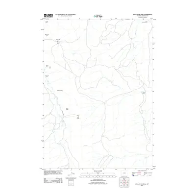
2012 Map of Hole-in-the-Wall
USGS Topo · Published 2012About this map
Hole-in-the-Wall serves as the namesake for this high-plains landscape, an area characterized by scattered homesteads and ranches tied to reliable water sources. Early 21st-century land use is reflected in the distribution of the Elmer Rinker Homestead, Ghent Homestead, and Poker Creek Ranch, connected by rugged routes like Buffalo Creek Rd. The topography is defined by dramatic vertical features such as Castle Rock, Steamboat Rock, and Poker Butte, while a network of seasonal watercourses including Buffalo Cr and Posey Cr drain the territory. Strategically located resources like Taylor Spring and Shearing Pens Spring suggest the ongoing importance of livestock management in this corner of Johnson County, while features such as Bar C Gap and Bar C Draw indicate historic land claims and pass-throughs.
Find a feature on this map
19 named features on this map. Tap any name to fly to it.
Don’t see what you’re looking for? This feature index may not catch every label — zoom into the map to look around manually.
Map Details
Editions of this 2012 Hole-in-the-Wall Map
This is the sole edition of this map. No revisions or reprints were ever made.
Other maps of this area

1955 · Arminto
USGS Topo · 1:250,000

1958 · Arminto
USGS Topo · 1:250,000

1961 · Barnum
USGS Topo · 1:62,500

1961 · TTT Ranch
USGS Topo · 1:24,000

1961 · Kaycee
USGS Topo · 1:24,000

1962 · Arminto
USGS Topo · 1:250,000

1968 · Willow Creek School
USGS Topo · 1:24,000

1968 · Roughlock Hill
USGS Topo · 1:24,000
1968 · Broken Horn Creek
USGS Topo · 1:24,000
1979 · Red Fork Powder River
USGS Topo · 1:24,000